

Description
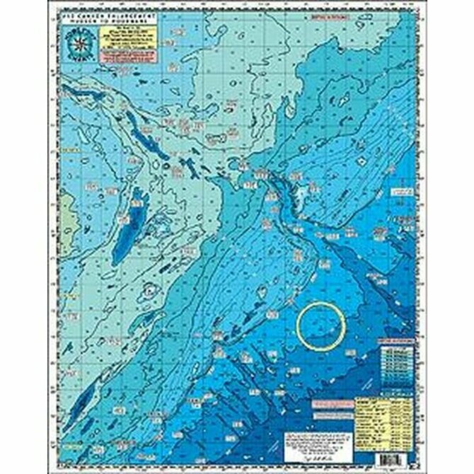
HPC 12 Hudson Canyon to the South Poorman's
CANYON CHART ENLARGEMENT
AWESOME BOTTOM STRUCTURE
Shows distances from each inlet to the Canyons!
30 Fathom Curve east past 1000 Fathoms
Shows: The Glory Hole, Hudson, Tom's, Berkely, Carteret, Lindenkohl, Spencer, Wilmington, Baltimore, Poormans and the South Poormans Canyons and 500 Fathom Lumps outside Washington Canyon
Laminated-waterproof
Color coded depth and contour curve lines
Peaks and Canyons shown with GPS LAT/LON coordinates
Fishing Grounds Shown: The Glory Hole, No Name Shoal, 42 Fathom Basin, The Point, The Flats, The Tongue, 200/100, The Bombs,Chicken Canyon, Jones Valley, Babylon Valley, The Letters, The Rabbit Ears, The Funnel, The Lobster Claw, The Elephant Trunk, The 500 Square, The West Notch, The 500 Fathom Lumps and many more.
Wrecks Shown with with GPS LAT/LON coordinates: Bacardi, Texas Tower, Olinda, Bidevind, Lexington, West Wreck, Larson, Huntington, Herb Parker, Haskell, U-869 Sub, Isabel Wiley, EH Cole, Carolina, Texel, Winneconne, USS Murphy, Rio Tercero, Sea Skip, Miss Arlene, India Arrow, and many more.
Depths in Fathoms